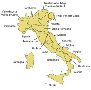
Italy, whose territory largely coincides with the homonymous geographical region, is located in Southern Europe and it is also considered a part of western Europe.
To the north, Italy borders France, Switzerland, Austria, and Slovenia and is roughly delimited by the Alpine watershed, enclosing the Po Valley and the Venetian Plain.
To the south, it consists of the entirety of the Italian Peninsula and the two Mediterranean islands of Sicily and Sardinia (the two biggest islands of the Mediterranean), in addition to many smaller islands. The sovereign states of San Marino and the Vatican City are enclaves within Italy, while Campione d’Italia is an Italian exclave in Switzerland.[190]
The country’s total area is 301,230 square kilometres (116,306 sq mi), of which 294,020 km2 (113,522 sq mi) is land and 7,210 km2 (2,784 sq mi) is water.
Including the islands, Italy has a coastline and border of 7,600 kilometres (4,722 miles) on the Adriatic, Ionian, Tyrrhenian seas (740 km (460 mi)), and borders shared with France (488 km (303 mi)), Austria (430 km (267 mi)), Slovenia (232 km (144 mi)) and Switzerland (740 km (460 mi)). San Marino (39 km (24 mi)) and Vatican City (3.2 km (2.0 mi)), both enclaves, account for the remainder.
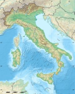
The Apennine Mountains form the peninsula’s backbone, and the Alps form most of its northern boundary, where Italy’s highest point is located on Mont Blanc (Monte Bianco) (4,810 m or 15,780 ft). Other worldwide-known mountains in Italy include the Matterhorn (Monte Cervino), Monte Rosa, Gran Paradiso in the West Alps, and Bernina, Stelvio and Dolomites along the eastern side.
The Po, Italy’s longest river (652 kilometres or 405 miles), flows from the Alps on the western border with France and crosses the Padan plain on its way to the Adriatic Sea. The Po Valley is the largest plain in Italy, with 46,000 km2 (18,000 sq mi), and it represents over 70% of the total plain area in the country.
Many elements of the Italian territory are of volcanic origin. Most of the small islands and archipelagos in the south, like Capraia, Ponza, Ischia, Eolie, Ustica and Pantelleria are volcanic islands. There are also active volcanoes: Mount Etna in Sicily (the largest active volcano in Europe), Vulcano, Stromboli, and Vesuvius (the only active volcano on mainland Europe).
The five largest lakes are, in order of diminishing size:
– Garda (367.94 km2 or 142 sq mi);
– Maggiore (212.51 km2 or 82 sq mi, whose minor northern part is part of Switzerland);
– Como (145.9 km2 or 56 sq mi);
– Trasimeno (124.29 km2 or 48 sq mi) and Bolsena (113.55 km2 or 44 sq mi).
Four different seas surround the Italian Peninsula in the Mediterranean Sea from three sides:
– the Adriatic Sea in the east
– the Ionian Sea in the south
– the Ligurian Sea
– the Tyrrhenian Sea in the west. The longest Italian river is the Po, which flows for either 652 km (405 mi) or 682 km (424 mi).
Most of the rivers of Italy drain either into the Adriatic Sea or the Tyrrhenian Sea.